AI as a tool for farming and land management

Artificial intelligence is a powerful tool that has the potential to uncover information efficiently and fast, leaving time for innovators to profit from the new knowledge. The terraPulse company does this with massive amounts of data from NASA and European Space Agency (ESA) satellites.
Image Credit -R. DiazThe company’s goals
This company aims to provide customers with local intelligence and support ecological decisions. TerraPulse uses Machine Learning (ML), a field of Artificial intelligence or AI, to supplement ground observations. Using ML models, terraPulse analyzes geospatial data from satellite imagery. ML saves countless hours humans would spend evaluating those observations and extracting information about phenomena, objects, or events on Earth’s surface.
In terraPulse, a team of experts in geospatial intelligence, machine learning, and satellite image analysis, streamline the supply of usable real-time data to users. With the large amount of satellite data available, the team can train the models, test them, and use them to make accurate predictions across various scenarios and timelines.
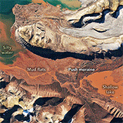
Image Credit -NASAServices provided

The global resolution maps, time series, and change analysis services from terraPulse help private companies and governmental organizations. Some examples of the applicable services are:
Identification of timber clearings across the southeastern United States. Information used by a pine seedling company looking to reach potential reforestation customers.
A biomass energy company verifying reforestation activities from suppliers harvesting wood for their mills.
Land brokers, insurance companies, investors, and developers looking for better information about a geographic area: how the conditions throughout time of an area meet the needs of a farm or a touristic development, determine the best views and hence value of cabin rentals, look at flood history to add preventive measures.
Cattle ranchers can influence range-management choices by tracking past and present vegetation health indices during the growing season.
Time domain or Temporal changes are also relevant to farmers. They might want to know, before planting, about possible changes to the land conditions, understand what natural resources are nearby, and monitor the characteristics of the land and wildlife habitat.
Using AI along with current and historical data, the company can also map the mix of vegetation on the ground, such as trees, bushes, and grasses. They can look at fires in the satellite record and tell how these changed the landscape.
Image Credit -terraPulseTerraView
Another service offered by terraPulse, terraView, monitors tree cover, deforestation, and other indices. It provides valuable data to inform the carbon market, which sets the value of forested areas left in a natural state and sells “carbon credits.”
terraView benefits companies and organizations involved in reforestation or paying individuals to maintain undeveloped land. Ensuring the reliability of the data is essential to landowners as well as companies purchasing the credits. It sets the credit value and ensures the carbon offset is maintained.
AI sets the stage for new companies.
Learning from terraPulse, we realize what ML can do with the wealth of data generated by the NASA and ESA satellites. It enables innovators and entrepreneurs to join forces in new ventures like terraPulse. With the current and future data from these satellites, Machine Learning can be used to extract other new and relevant information that can spearhead a new company. So, let’s wait and see who comes up with a new use.
If you have information about other companies taking advantage of this data, please share it in the comments.